How threatened by earthquakes are US communities? New report gives answers
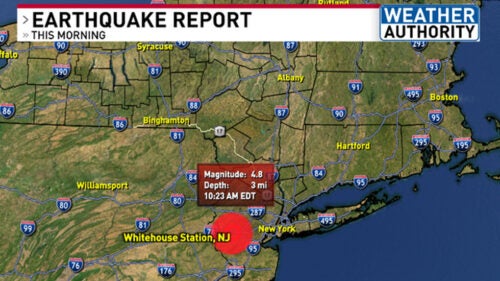
When it comes to earthquakes in the United States, California springs to mind as the nation’s hotspot. But the rest of the country is far from immune, as residents in the New York City region were reminded on April 5 by a magnitude 4.8 temblor centered nearby in New Jersey.
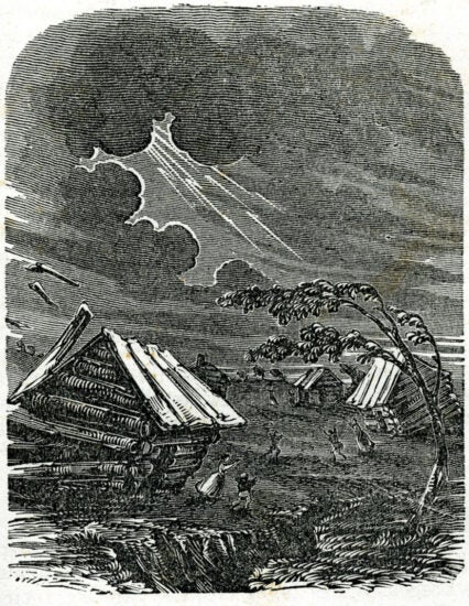
Even citizens of the nation’s interior face a threat. Over several months in the early 1800s, for example, numerous earthquakes — some reaching magnitude 7.5 or higher — devastated a massive area radiating from the Mississippi River town of New Madrid, Missouri.
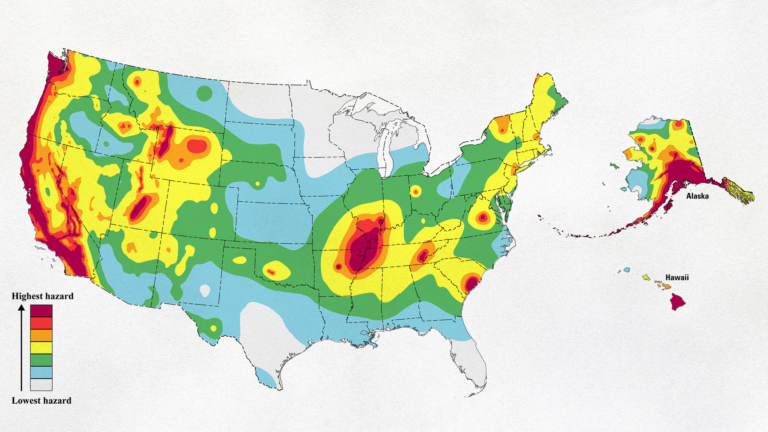
Earlier this year, the U.S. Geological Survey updated a national resource that engineers, policymakers, government agencies and others use to assess risk of damage from earthquakes throughout the country. The Statewide California Earthquake Center (formerly Southern California Earthquake Center) based at the USC Dornsife College of Letters, Arts and Sciences, contributed crucial results to the update.
USC alumnus helps shape new earthquake report
The revised National Seismic Hazard Model, which includes a comprehensive approach for all 50 states, uses much of the methodology developed from California’s model to offer insights into the seismological underpinnings of the entire Western United States.
USC alumnus Kevin Milner helped build the new model and co-authored the USGS report, and he wrote a companion paper that offers technical details. He completed the work that went into the report while at USC.
Milner, who recently joined USGS, spent more than 17 years working at SCEC headquarters at USC Dornsife, starting as an undergraduate intern while earning a bachelor’s degree from USC Viterbi School of Engineering. He then landed a staff position at SCEC and earned a master’s degree and a PhD from USC Dornsife while working full time.
He notes that previous versions of the report separately covered the contiguous U.S., Alaska and Hawaii. “This is the first time that a comprehensive update has been done for all 50 states at the same time,” he says.
In the new report, researchers applied their methodology developed for California to more areas around the West. In California, the risk went up slightly, but the model didn’t change very much — and that’s mostly because the science in the state was already so advanced to start with, says Yehuda Ben-Zion, director of SCEC. The model was already being used a decade ago for California.
“It has morphed; it has changed a little bit for California by improving some components, but that’s not dramatic,” says Ben-Zion, professor of Earth sciences at USC Dornsife. “The reason is because we know more here.”
USC’s advanced computer resources aid modeling
There are two main components of the model: The kind of earthquake shaking that might happen at a particular location, known as the “ground motion model”; and the probability of earthquakes happening at different locations, called the “earthquake rupture forecast.”
Milner works on developing the earthquake rupture forecasts. He says the model represents the work of about 50 scientists, including geologists in the field who are mapping faults and finding the rate at which they move each year, scientists who dig trenches to look for evidence of ancient earthquakes, and those who look at the rate of seismic activity across the U.S.
Creating the earthquake rupture forecast requires immense computation, which USC’s Center for Advanced Research Computing handled. To generate the final model, 38 nodes (individual computers with 20 processors each that work together to tackle large calculations) took more than two days, but Milner says he was “spitting out models continuously over the course of more than a year — models and diagnostic hazard calculations using really big amounts of computation.”
The information from the update will eventually be incorporated into building codes and structural designs to help create safer dwellings for people. It’s also used by insurance companies to figure out rates for different areas that may be at risk of earthquakes.
What’s shaking for the future?
Last year, the Southern California Earthquake Center became the Statewide California Earthquake Center to reflect a major new proposal that was funded to expand the work that SCEC was doing — which now spans the region from western Nevada to south of the Mexico border. Earthquake faults don’t respect boundaries, so the center also adjusted to reflect the work it was doing, Ben-Zion says.
Now that the report is out, there are already new avenues of research. Milner is interested in earthquakes that begin in one fault and then jump to another — the type that wreaked havoc on Turkey and Syria last year. He’s also interested in building in a time-dependent model of earthquakes, one that takes into consideration the amount of time that has elapsed since the last major event.
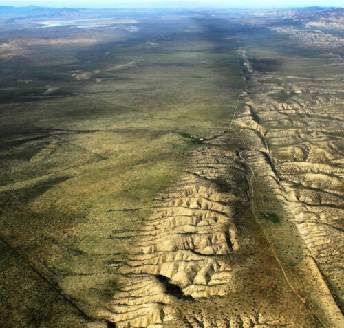
In Southern California, the San Andreas Fault — which forms the boundary between the large Pacific and North American plates — has gone without a major earthquake since 1857. Researchers believe that the average time between major events is shorter than the 167 years that have so far elapsed, suggesting the fault is overdue for a large rupture.
Milner says building time dependence more deeply into future models will help estimate risk more accurately.
Researchers can forecast earthquakes with limited success, says Ben-Zion, but he adds that the precision is improving with machine learning and more data. He equates the situation to a doctor trying to forecast when a person will die. The statistical life expectancy may be known within a range of years to weeks, and with more precise tests the range can be narrowed, but the exact time of death remains unpredictable.
“We cannot predict exactly when big earthquakes will come, but they are going to happen,” says Ben-Zion. “We need to invest in making the communities — the buildings, infrastructure and population — more resilient.”